After Lismore where will the storms and floods go next
The extreme weather dumping heavy rain and causing severe flooding in Queensland and northern NSW is heading south, in an ominous warning for the Mid North Coast, Sydney and the South Coast.
Authorities are warning that the weather system is tracking south and advising communities further afield to prepare now while they have time.
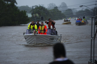
Rescue workers on swollen waters amid Lismore's flood.Credit:Elise Derwin
"We expect these weather conditions to move further south over the course of the week, particularly towards the back end of the week," NSW Premier Dominic Perrottet said.
The Bureau of Meteorology issued a flood watch on Monday afternoon for the Mid North Coast, the Central Coast, Greater Sydney, the Illawarra and the South Coast. There are several major flood warnings for rivers in the state's north, and minor to moderate flood warnings on the Mid North Coast.
SES Commissioner Carlene York said that, even with the best forecasting, it was tricky to know exactly which areas would be worst affected.
"The issues with these types of east coast lows is that it just depends where it goes - how close to the coast and what path it travels. And then the unknown is where it will actually drop the heaviest rainfall," she said.
Lismore, which is experiencing one of its worst floods on record, will get a breather on Tuesday and Wednesday with only one or two millimetres of rain forecast, before heavier falls of up to 20 millimetres on Thursday and Friday.
Coffs Harbour and Port Macquarie are forecast to receive up to 25 millimetres each day between Tuesday and Monday.
The heaviest falls in Sydney are predicted to be on Tuesday and Wednesday with up to 70 and 90 millimetres on those days.
On the South Coast, Kiama is forecast to get up to 80 millimetres on Tuesday and 150 millimetres on Wednesday, and Batemans Bay is bracing itself for similarly heavy falls on Wednesday and Thursday.
Kempsey mayor Leo Hauville said all the low-level bridges along the Macleay River were already covered by floodwater and his community was bracing themselves for rising waters.
"If the weather system continues to travel south it'll get to us in 24 hours," he said, noting farmers were moving stock to higher ground.
"The whole area is wary and watching and hoping for the best."
The bureau is predicting the Macleay River at Kempsey could reach minor flood level of 4.5 metres on Tuesday night.
The widespread nature of the floods up and down the coast will stretch the state's disaster resources. Commissioner York said her agency resisted sending more people up north to ensure there was capacity down south when needed.
"We have moved extra members up into the Northern Rivers district, but also we have retained our volunteers and other emergency service partner members down on the South Coast to make sure that they are in the stages of planning, and also getting messaging out and communication out to the community to prepare them for this event as it comes through," she said.
Commissioner York said, while Sydney could get heavy rain, it was unlikely to be as heavy as the storms up north, but could still lead to flash flooding.
"That is affected by the amount of saturation that's in the land at the moment that there is no way for the water to run as it falls onto the ground, which will cause flash flooding and that's a very dangerous situation for any motorists."
The SES reminds people in flood-affected areas:
Belum ada Komentar untuk "After Lismore where will the storms and floods go next"
Posting Komentar